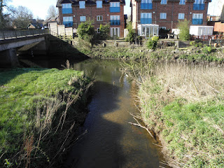
Scotch Brook starts it's life in the fields at Knenhall near Moddershall,

The Brook winds it way south parallel to Longton road A520 and then meets the road a bit further after passing Mill Lane and enters Moddershall conservation area.
A Bone mill (Hays Mill) is about half way down the length of the brook after it has crossed under the Longton road.
A Bone mill (Hays Mill) is about half way down the length of the brook after it has crossed under the Longton road.
| NGR | SJ 913 351 |
| Latitude | 52.913253 |
| Longitude | -2.1308197 |
Just a bit further down is Coppice Mill an old flint works that was powered by the brook.
| NGR | SJ 908 347 |
| Latitude | 52.909649 |
| Longitude | -2.1382435 |
Ruining passed the Mill Hotel the then brook goes under the railway line by Morrison's store and flows towards the town centre.
At the end of the Morrison's car park the brook flows in to a culvert which takes it under the town to reappear briefly by the Tent and Mersey canal. It then runs under the canal and near the locks and comes out the other side.
The flood managment system in action after a heavy downpour.
One of the Natural Flood Management schemes completed at Scotch Brook to store both water and sediment to help reduce flood risk, as well as benefiting wildlife— StaffsWildlife 🦔🍄🦇 (@StaffsWildlife) March 13, 2019
The scheme completed on private farmland,was funded by @EnvAgencyMids & Trent Flood & Coastal Risk Management Committee pic.twitter.com/8xfdt1xSJt
.png)


No comments:
Post a Comment